
How Geofencing Improves Route Efficiency
Michael Bar
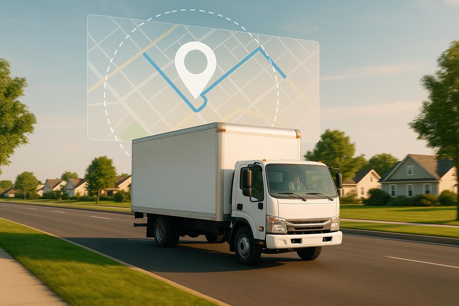
Geofencing helps fleet managers improve route efficiency, cut costs, and enhance security. It uses GPS and other technologies to create virtual boundaries around locations. When a vehicle crosses these boundaries, actions like notifications or logs are triggered in real time. Here’s how it addresses common challenges:
- Prevents Route Deviations: Alerts managers if vehicles stray from planned routes, saving fuel and time.
- Reduces Traffic Delays: Real-time tracking allows dynamic rerouting to avoid congestion.
- Improves Security: Notifies managers of unauthorised movements, helping prevent theft.
- Automates Reporting: Logs entry/exit times automatically for easier compliance and analysis.
For example, logistics companies using geofencing have cut operational costs by up to 15% while improving delivery reliability. Tools like GRS Fleet Telematics integrate geofencing with detailed reporting and real-time alerts, offering an affordable and effective solution for UK fleets.
Utilizing Geofences | LANA Fleet Feature Spotlight
Common Fleet Route Management Problems
Fleet operators across the UK grapple with a variety of challenges that not only disrupt efficiency but also inflate operational costs. These issues often feed into one another, creating a frustrating cycle of inefficiency that can be hard to break without the right tools and oversight.
Route Deviations and Unauthorised Stops
Route deviations - whether through unauthorised stops or straying from planned routes - can derail carefully crafted schedules and budgets. These unplanned changes often occur due to incorrect routing or stops being made out of sequence.
Fuel, a significant expense for any fleet, accounts for over a quarter of total operational costs. With a projected shortfall of 160,000 skilled drivers by 2030, making the most of existing resources has never been more crucial. When deviations occur, they not only waste fuel but also create a ripple effect of inefficiencies, including increased delays caused by traffic and disrupted schedules.
Traffic Congestion and Poor Route Selection
Even when routes are followed as planned, external factors like traffic congestion can wreak havoc on schedules. Poor route selection only makes matters worse, leading to unpredictable delivery times and a cascade of delays that disrupt operations throughout the day.
The financial toll of congestion is staggering. In 2022, it cost the trucking industry £108.8 billion, a sharp rise from £94.6 billion in 2021. To put this into perspective, this level of delay is equivalent to over 430,000 commercial truck drivers sitting idle for an entire work year. On average, each registered combination truck incurred a cost of £7,588 due to these delays. Beyond fuel wastage, time spent in traffic accelerates vehicle wear and tear, reduces productivity, and often forces companies to deploy additional resources to meet delivery deadlines.
"With rising costs putting pressure on businesses and consumers alike, minimizing delays caused by congestion is more important than ever. Addressing these challenges requires a shared commitment to modernize our infrastructure and strengthen the backbone of our economy: resilient and efficient supply chains."
– Frank Granieri, A. Duie Pyle chief operating officer of Supply Chain Solutions
These figures highlight the urgent need for smarter, real-time route management to mitigate the impact of congestion and improve overall efficiency.
Limited Real-Time Visibility
A lack of real-time visibility leaves fleet managers operating in the dark. Without up-to-the-minute location data, they struggle to respond effectively to traffic jams, vehicle breakdowns, or last-minute customer changes. This often results in missed opportunities to optimise operations - such as rerouting vehicles, reallocating tasks to nearby drivers, or adjusting schedules to maintain efficiency.
According to research, 37% of respondents reported limited use of advanced planning and scheduling systems, making it harder to make informed decisions or measure success effectively. This gap not only disrupts operations but also increases security risks like theft and loss, while delayed responses become a frustrating norm.
"When a fleet manager's dealing with collaboration that's really dysfunctional, it's just impossible for them to know what's going on at their organization. But software does give you the opportunity to pull everyone in and collaborate in one place."
– Dan Simpson, Product Marketing Manager, Fleetio
Without real-time oversight, even the best-laid plans can quickly unravel as conditions change. Traffic flows shift, customer needs evolve, and unexpected vehicle issues arise, leaving managers unable to adapt in the moment. However, tools like geofencing and real-time tracking can turn these blind spots into actionable insights, enabling faster and more effective decision-making.
How Geofencing Technology Works
Geofencing tackles route inefficiencies by transforming physical locations into digital zones that trigger automated actions when certain conditions are met.
"A geofence can be defined as a virtual fence around a delimited geographical location. Geofencing is the use of this digital fence to trigger an action when entering or leaving this perimeter."
At its core, this technology combines GPS positioning data with mapping software to create these virtual boundaries. While geofences are entirely digital, their impact on fleet management operations is tangible and measurable.
Creating Virtual Boundaries
The process of setting up geofences starts with mapping software, which allows fleet managers to outline boundaries around specific locations on a digital map. These boundaries are typically drawn around critical points such as delivery sites, depots, or restricted zones. Managers can adjust these zones to align with GPS accuracy, ensuring precision.
In addition to GPS, geofencing systems can also incorporate RFID, Wi‑Fi, and cellular data to enhance functionality.
The setup process generally involves the following steps:
- Selecting a fleet management platform.
- Defining the geofence area on a digital map.
- Establishing rules and alerts for boundary crossings.
- Assigning the geofence to specific vehicles or assets.
- Regularly reviewing and updating boundaries to meet changing operational needs.
Once these zones are defined, they integrate seamlessly with real-time monitoring systems, ensuring that vehicles stick to their assigned routes and operational plans.
Real-Time Monitoring and Alerts
After geofences are in place, GPS-equipped vehicles continuously transmit their location data to the fleet management system. The moment a vehicle crosses a geofence boundary - whether entering or exiting - the system triggers automatic actions.
These actions include sending instant notifications, logging arrival or departure times, and alerting the relevant personnel. The real-time nature of this system ensures that managers receive updates as events occur, eliminating the delays associated with manual reporting.
Customisable alerts make the system even more effective. Fleet managers can tailor notifications to suit different scenarios:
- Urgent alerts for vehicles entering restricted zones.
- Routine updates for scheduled arrivals.
- Security notifications for unauthorised movements outside operating hours.
This real-time visibility addresses a common problem in fleet operations: delayed responses to route deviations or unauthorised stops. With geofencing, managers can act immediately - rerouting vehicles, contacting drivers, or adjusting schedules to keep operations running smoothly.
"Organizations need to understand what the key areas of focus are and what they are trying to achieve from the business point of view." - Avi Shua, co-founder and chief innovation officer at Orca Security
Key Benefits of Geofencing for Route Efficiency
Tackling route management challenges starts with gaining accurate, real-time insights - something geofencing delivers across fleet operations. This technology helps improve route efficiency by addressing inefficiencies, bolstering security, cutting costs, and simplifying daily processes.
Better Route Adherence
Geofencing ensures drivers stick to approved routes by setting up virtual boundaries around designated areas and tracking compliance in real time. If a vehicle strays from its planned path, the system immediately notifies fleet managers, allowing them to verify whether the deviation was authorised and take action if necessary.
"Geofence tracking devices minimise deviations and boost efficiency." - Radius
These instant alerts enable fleet managers to respond quickly, shifting route management from a reactive to a proactive approach. By defining specific routes or operational zones, managers can monitor adherence, optimise planning, cut down on unnecessary deviations, and save on fuel costs.
Logistics companies benefit significantly from this feature. For example, geofencing can trigger automatic SMS or email updates to customers when delivery vehicles enter a set radius around their address. Similarly, fleets carrying heavy goods can avoid restricted zones, like weight-limited or low-emission areas, by using automated alerts.
Beyond route adherence, real-time data also enables better resource management.
Dynamic Resource Allocation
With real-time location data, fleet managers gain precise visibility of vehicle positions, enabling smarter, more flexible resource allocation. This data allows for quick rerouting to handle urgent deliveries and fine-tuning schedules to match current conditions.
The system also tracks how long vehicles spend at various points, such as rest stops, loading bays, or job sites. Fleet managers can use this information to reassign resources, redirect vehicles for priority tasks, or adjust schedules dynamically.
Geofencing integrates seamlessly with maintenance systems, automatically monitoring vehicle usage and scheduling timely servicing. This proactive approach helps prevent unexpected breakdowns, ensuring vehicles stay in top condition and avoid disruptions to route efficiency.
Improved Security and Theft Prevention
Cargo theft remains a serious concern, but geofencing enhances security by offering real-time monitoring and alerts for unauthorised movements. If a vehicle leaves its designated area, fleet managers receive instant notifications, enabling swift action.
"With geofencing in fleet tracking, managers get instant alerts if a vehicle moves out of its designated area. This feature helps prevent theft and unauthorised vehicle usage, ensuring assets remain protected." - Fleet Pins
Geofencing doesn’t just deter theft; it also aids in recovery by pinpointing a vehicle’s location if it’s stolen. Managers can set up geofences around storage facilities or high-risk zones to receive immediate alerts if a vehicle enters or exits unexpectedly. By keeping vehicles on their intended routes and reducing the risk of theft, geofencing contributes directly to smoother operations.
In addition to bolstering security, automated logging simplifies compliance and operational reviews.
Automated Reporting and Compliance
Manual tracking can be time-consuming and prone to errors. Geofencing automates these processes, generating accurate entry and exit logs that eliminate the need for manual reporting while offering detailed records of geofence breaches.
This automation streamlines tasks like check-ins when vehicles enter a geofenced area. The system also provides actionable insights into route performance, driver behaviour, and operational trends. These insights help refine future planning and resource allocation without adding to administrative workloads.
For fleets operating under strict regulations or service agreements, automated compliance reporting proves especially useful. It ensures adherence to delivery timeframes and route standards, keeping operations efficient and reliable.
Integrating Geofencing with GRS Fleet Telematics
GRS Fleet Telematics takes geofencing beyond simple tracking by using GPS technology to create digital boundaries around key locations like offices, customer sites, and secure areas. These virtual boundaries trigger automatic actions, helping businesses improve security, streamline operations, and cut costs.
The system features a dual-tracker setup, pairing a primary wired GPS tracker with a hidden Bluetooth backup. This combination achieves an impressive 91% vehicle recovery rate. With this setup, fleet managers benefit from immediate alerts and precise reporting, ensuring nothing is missed.
Real-Time Tracking and Alerts
With geofencing at its core, real-time tracking adds an extra layer of operational control. GRS Fleet Telematics sends instant notifications whenever a vehicle crosses a designated boundary or enters a new area. These alerts allow fleet managers to stay informed about critical movements without needing to constantly monitor screens. For example, if a vehicle unexpectedly leaves an authorised zone, the system sends an alert, helping to prevent unauthorised use and maintain security.
"Our tracking systems for cars provide peace of mind with real-time alerts and location updates. The Ultimate package even offers remote immobilisation capabilities, giving you complete control over your vehicles' security."
Fleet managers can monitor operations through web and mobile apps, enabling them to respond quickly to route deviations or unexpected situations. Geofencing also encourages drivers to stick to planned routes, boosting accountability and ensuring schedules are met.
Detailed Reporting and Insights
GRS Fleet Telematics doesn’t just provide real-time updates - it also generates detailed reports on fuel consumption, maintenance needs, and performance. By integrating geofencing data, the system offers insights into how vehicles interact with designated zones and routes. It automatically logs entry and exit times for all geofenced areas, creating a reliable record that’s invaluable for verifying customer site visits and ensuring compliance with operating hours or restricted zones.
These insights allow fleet managers to refine routes and improve overall efficiency. For instance, one client reported monthly savings of £1,224.52, annual savings of £14,694.25, and an ROI of 2,965%, with a payback period of just 0.3 months.
"It gives you everything you need to know about where, when and how long any truck is somewhere at any given time. It really helps with tracking the actual 'on the job site' time." - Vicki Laake, Papalia Plumbing & Heating
The mobile app further enhances flexibility, granting remote access to geofencing data and detailed reports. Whether in the office or on the go, decision-makers can adapt swiftly to operational changes.
GRS Fleet Telematics offers this geofencing integration at competitive prices, with hardware starting at £35 and monthly subscriptions from £7.99 per vehicle. Professional installation is included free with Fleet Branding, ensuring a smooth and cost-effective setup.
Conclusion and Key Takeaways
Geofencing technology has reshaped fleet management by addressing persistent inefficiencies in routing. By curbing unauthorised route changes and offering real-time visibility into vehicle movements, it helps improve operational efficiency, ensures route compliance, and keeps costs under control.
But geofencing doesn’t stop at tracking. It enables dynamic resource allocation, enforces better route adherence, and automates compliance reporting - eliminating hours of manual work. It also enhances driver accountability and equips fleet managers with actionable insights. These practical benefits make geofencing a valuable tool for fleet operators in the UK, with integrated solutions like those from GRS Fleet Telematics leading the way.
For businesses aiming to adopt geofencing, GRS Fleet Telematics offers a robust solution that combines advanced tracking features with affordability. Their system provides real-time alerts, detailed reporting, and competitive pricing, ensuring high recovery rates and a strong return on investment.
Security is another critical advantage. With cargo theft in the EMEA region surging by nearly 700% in 2023 - causing losses of €552,199,741 - geofencing plays a crucial role in safeguarding fleet assets and protecting investments.
FAQs
How does geofencing help fleet managers reduce operational costs?
Geofencing offers fleet managers a smart way to reduce operational costs by streamlining routes. With virtual boundaries in place, vehicles can stick to the most efficient paths, cutting down on unnecessary mileage and fuel use while avoiding delays from detours or heavy traffic.
On top of that, geofencing sends real-time alerts if a vehicle enters restricted or risky areas, allowing managers to act quickly and reduce potential risks or downtime. It also boosts security by keeping track of vehicle locations and helping prevent unauthorised use, which can save money by reducing losses from theft or misuse.
What technology is needed to use geofencing in fleet management?
To set up geofencing in a fleet management system, a few essential technologies come into play. GPS tracking forms the backbone, allowing real-time monitoring of vehicle locations. Alongside this, geofencing software is used to define and manage virtual boundaries. For added precision and functionality in certain scenarios, technologies like Wi-Fi triangulation, Bluetooth Low Energy (BLE) beacons, or RFID can be integrated. These tools work together to provide accurate location tracking and automated alerts, streamlining routes and boosting fleet efficiency.
How does geofencing enhance vehicle security and prevent unauthorised use or theft?
Geofencing adds an extra layer of security to vehicles by setting up virtual boundaries around specific areas. If a vehicle moves beyond these boundaries without permission, alerts are sent out immediately. This allows fleet managers to act quickly, helping to deter theft and prevent unauthorised use.
Beyond security, geofencing also provides businesses with greater oversight of their fleet operations. By tracking vehicle movements in real time, it reduces the chances of misuse and ensures vehicles are being used strictly for their intended purposes.
Related Blog Posts
Related Articles
5 Jul 2026
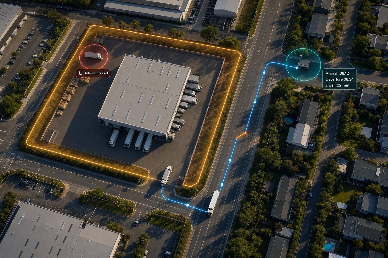
Geofencing for Fleet Management: How It Works
Turn vehicle GPS pings into arrival/departure logs, dwell-time, route-deviation checks and after-hours alerts for fleets.
5 Jul 2026
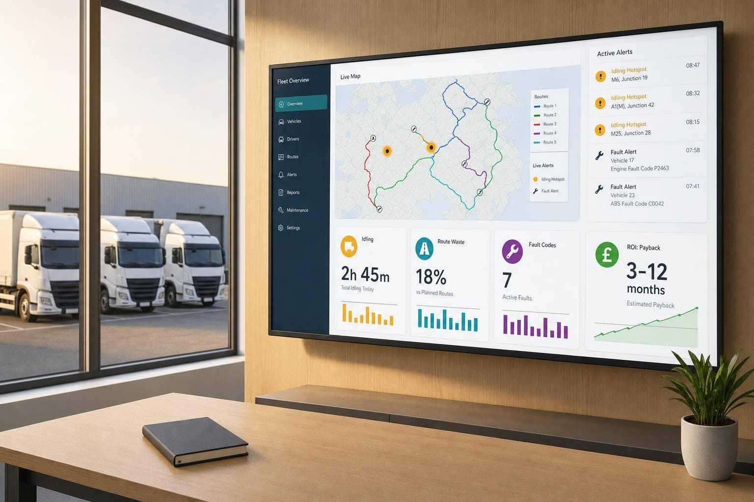
Telematics Data Visualisation: ROI for Fleet Operators
Telematics dashboards reveal idling, route waste and fault codes to cut fuel, maintenance and incidents and show ROI at 3–12 months.
5 Jul 2026
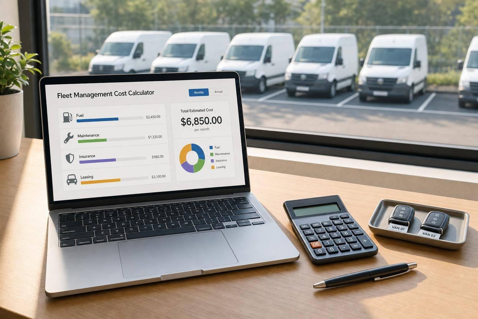
Fleet Management Cost Calculator
Estimate monthly or annual fleet running costs, compare cost categories, and plan budgets with a practical fleet management cost calculator.