Integrating Drones with Fleet Telematics Systems
Combining drone and van telematics transforms UK fleet operations—faster deliveries, lower costs and tighter security under GDPR.
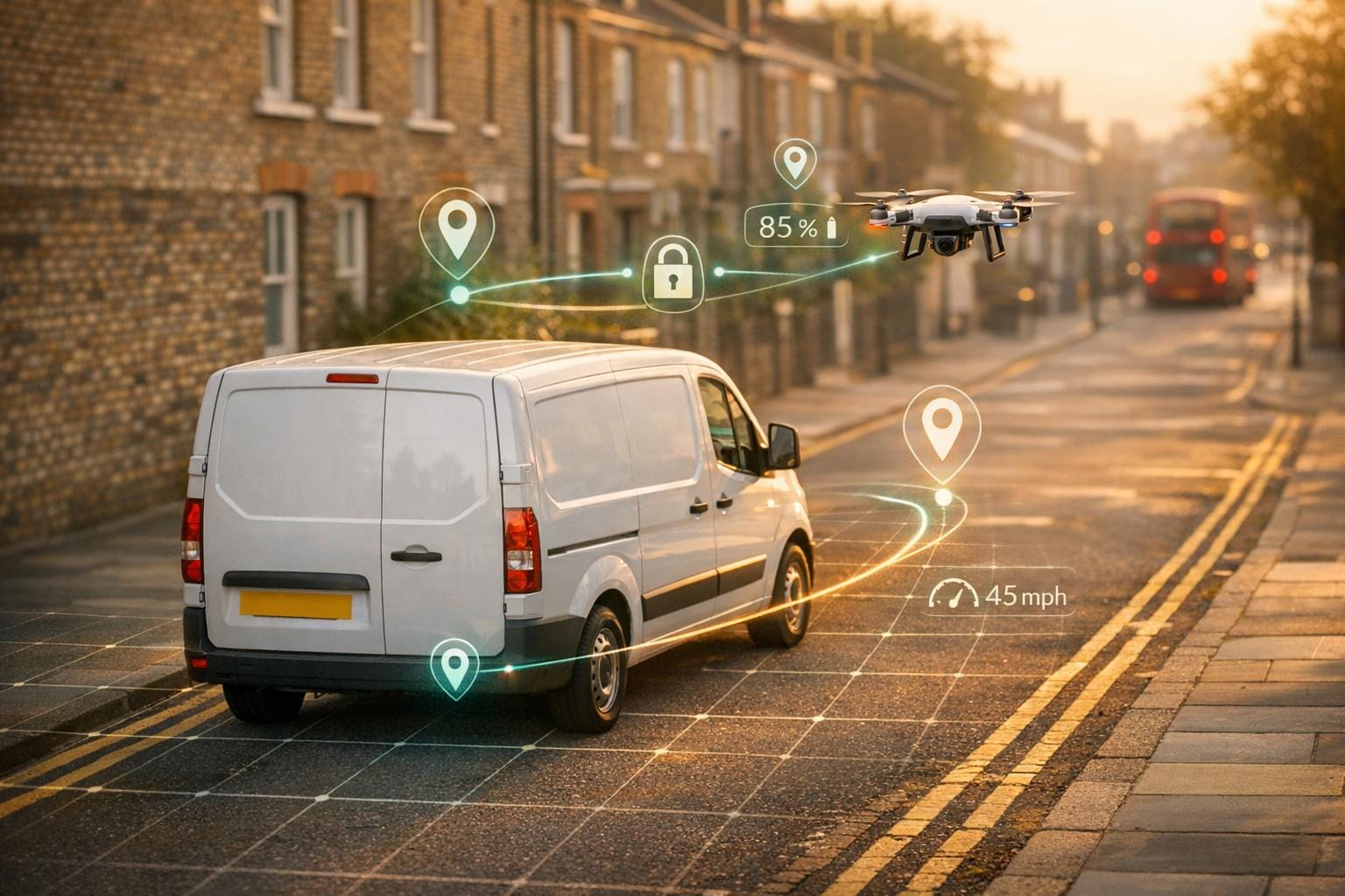
The integration of drones with fleet telematics systems is transforming delivery and fleet operations in the UK. By combining aerial and ground data, logistics managers gain real-time visibility, cutting delivery times and reducing costs. Key advancements include:
- Improved efficiency: DHL UK's 2023 pilot reduced delivery times by 62% and saved £150,000 annually.
- Enhanced data management: Drones use AI sensors and telemetry protocols like MQTT for seamless communication with fleet systems.
- Cost savings: Cloud platforms like AWS IoT offer scalable solutions, and GRS Fleet Telematics provides affordable van tracking starting at £7.99/month.
- Security compliance: Encryption, geo-fencing, and GDPR adherence ensure safe and lawful operations.
For small fleets, GRS Fleet Telematics offers simplicity and affordability. Larger fleets benefit from the scalability of cloud-based platforms. Choosing the right system depends on your fleet size, budget, and operational needs across various industries.
Meet FlytBase: The Enterprise Drone Autonomy Platform
sbb-itb-499a7f0
Technologies Enabling Drone-Fleet Integration
Integrating drone fleets into broader systems hinges on three main technologies: AI sensors, telemetry protocols, and cloud infrastructure. Let’s break down how each of these elements plays a role.
AI sensors, such as cameras, LiDAR, and thermal imaging devices, are mounted on drones to handle tasks like object detection, obstacle avoidance, and real-time mapping. These sensors use machine learning to process data directly on the drone - known as on-edge processing. This approach allows drones to analyse data and send only the necessary insights to fleet systems, which cuts down on bandwidth use and speeds up decision-making. In fact, latency for real-time operations can dip below 100 milliseconds, enabling swift and efficient responses.
Communication Through Telemetry Protocols
To ensure drones communicate effectively with fleet platforms, telemetry protocols like MQTT and CoAP are used. MQTT, for instance, is ideal for lightweight messaging, which includes transmitting GPS coordinates, battery levels, and payload information without using up too much bandwidth. When combined with 5G-enhanced LTE networks - now available across many UK cities - these protocols allow fleet managers to monitor drone and van operations simultaneously in near real-time.
A great example of this in action is DHL UK’s integration of drones with Verizon Connect in early 2024. Using MQTT and AWS IoT, they improved delivery operations, cutting delivery times by 22%, saving 15% on fuel, and achieving 98% on-time deliveries across 500 operations [DHL Case Study Report, April 2024]. This kind of seamless communication is what enables more efficient and reliable fleet management.
The Role of Cloud Infrastructure
Cloud platforms like AWS IoT and Azure IoT Hub bring all these elements together. They offer scalable storage and analytics capabilities, merging drone telemetry with data from ground vehicles into unified dashboards. These systems are designed to handle large volumes of data while adhering to GDPR standards for operations in the UK.
One standout example is GRS Fleet Telematics, which uses open APIs and dual-tracker technology to integrate aerial and ground data. Their white-label van tracking solutions, starting at just £7.99 per month, boast a 91% stolen vehicle recovery rate. These devices can overlay drone data to enhance security and provide real-time monitoring for van fleets, making operations smoother and more secure [context].
Edge Computing for Greater Efficiency
While cloud infrastructure handles centralised analytics, edge computing adds another layer of efficiency, especially in dynamic environments. Drones process data locally onboard, which reduces the amount of information that needs to be transmitted to the cloud. This is particularly useful in rural areas with spotty 5G coverage, as it ensures operations remain responsive while cutting costs by up to 30%. Together, cloud and edge computing create a balanced system that supports both urban and rural drone operations effectively.
These technologies collectively form the backbone of modern drone-fleet integration, enabling faster, smarter, and more reliable operations across the UK.
1. GRS Fleet Telematics
Data Integration Capabilities
GRS Fleet Telematics seamlessly combines drone data and van tracking using open APIs and dual-tracker technology. With REST and WebSocket endpoints, it integrates drone telemetry - covering flight paths, battery levels, and payload details - alongside vehicle data into a single dashboard. This setup automates tasks like flight planning, maintenance updates, and performance analysis, streamlining operations.
Customisable dashboards cater to diverse operational needs, whether it's managing delivery routes across London or overseeing inspections in the Scottish countryside. Real-time data synchronisation ensures aerial and ground fleet movements are displayed together, offering managers complete visibility over mixed operations.
Security Features
Security is a cornerstone of the GRS Fleet Telematics platform. It uses Role-Based Access Control (RBAC), limiting access to sensitive drone data and command capabilities to authorised users only. To protect communications, all data between drones and the system is encrypted, safeguarding telemetry and media from unauthorised access.
Detailed audit logs record every action, flight, and maintenance activity, ensuring a full traceable history for compliance and operational reviews. This level of transparency is particularly valuable for UK businesses navigating GDPR while managing both drone and vehicle fleets.
Scalability for Mixed Fleets
The platform's ability to scale makes it indispensable for operations involving more than a few drones or multiple pilots, where manual tracking quickly becomes impractical. It centralises flight logs, maintenance schedules, and pilot certifications, integrating them with van tracking data. This eliminates the need for scattered records and emails, providing a streamlined approach for growing UK fleets.
With pricing starting at £7.99 per vehicle per month, the system offers an affordable solution for scaling operations. Its hardware-agnostic design supports various drone models alongside van trackers, giving flexibility whether you choose the Essential (£35), Enhanced (£79), or Ultimate (£119) tracking hardware packages.
2. Cloud-Based Telematics Platforms with Drone APIs
Data Integration Capabilities
Cloud-based telematics platforms use APIs to connect drones with ground systems, enabling real-time data exchange. These platforms rely on standard protocols like MQTT and RESTful APIs to gather drone telemetry - such as GPS data, altitude, battery levels, and camera feeds - alongside traditional van tracker systems monitoring location and speed. By combining drone and vehicle data into a single dashboard, these systems simplify management across both aerial and ground assets, allowing for seamless monitoring.
Technologies like Apache Kafka and edge computing ensure near-instant data synchronisation - under one second - while cutting bandwidth costs by 30%. For example, a UK logistics company integrated drone APIs into their telematics system and achieved 25% faster delivery times by coordinating drones to hand off packages to waiting vans. This integration not only improves efficiency but also strengthens operational security.
Security Features
Security measures in these platforms are robust, using AES-256 encryption for end-to-end data protection and OAuth 2.0 for API access control. Role-based access control and multi-factor authentication limit access to sensitive drone data and commands. To prevent DDoS attacks, API gateways regulate request traffic, while zero-trust frameworks verify drone data with digital signatures before it’s merged with fleet information.
Geo-fencing alerts add another layer of security, reducing hijacking risks for drone operations by 40% in UK trials. Blockchain auditing ensures tamper-proof logs of drone activity, helping businesses stay GDPR-compliant - an essential aspect for UK companies managing mixed fleets.
Scalability for Mixed Fleets
Auto-scaling Kubernetes clusters allow these platforms to handle over 10,000 assets without performance issues, accommodating petabyte-scale storage for drone video feeds. In June 2023, UPS tested Geotab's MyGeotab API with a fleet of 500 drones and 5,000 vehicles. Under project manager Lisa Chen, the trial reduced route planning time by 42% and cut fuel consumption by 18%, saving 1.2 million litres. Similarly, Amazon's Prime Air trials in the UK scaled drone operations alongside 200+ ground vehicles, processing 5TB of data daily using AWS IoT Core.
Platforms like Geotab can support up to 500,000 vehicles and drones, maintaining sub-one-second latency for API calls. This makes them a viable option for large-scale operations across the UK, ensuring both efficiency and cost-effectiveness.
Cost Efficiency
Pay-as-you-go pricing models bring notable savings. For instance, AWS IoT Core charges £0.08 per million minutes of drone connectivity and offers a free tier for the first 500,000 minutes. Serverless computing reduces idle costs by 70%, while predictive analytics - powered by drone aerial data - cuts fuel usage by 15% through better route planning. UK fleets typically see a return on investment within six months, with cost reductions ranging from 20–35%.
In early 2024, DHL integrated drones with Samsara's cloud telematics via API, under the leadership of Logistics Director Mark Thompson. By synchronising drone delivery scans with 10,000 van trackers, they achieved 28% faster last-mile delivery and £1.2 million in annual savings. A UK parcel service also saved £50,000 annually by integrating 50 drones, with breakeven typically occurring at around 100 assets, according to total cost of ownership calculators.
Advantages and Disadvantages
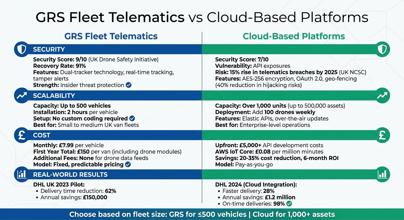
GRS Fleet Telematics vs Cloud-Based Platforms: Security, Scalability and Cost Comparison
UK fleet operators face a balancing act when integrating drones with fleet telematics, juggling security, scalability, and cost. Building on the earlier discussion about seamless data synchronisation, let's explore the operational benefits and challenges of different models.
When it comes to security, GRS Fleet Telematics stands out with its dual-tracker technology. This system achieves an impressive 91% recovery rate, thanks to real-time tracking and tamper alerts for both vans and drones. According to the UK Drone Safety Initiative, it scores 9/10 for insider threat protection. In comparison, cloud platforms score 7/10, as they are more vulnerable to cyber threats, particularly from API exposures. This is a growing concern, with UK NCSC data revealing a 15% rise in telematics breaches by 2025. However, GRS is specifically tailored for UK van fleets, which may limit its scalability for logistics firms expanding into autonomous vehicles.
On the other hand, cloud platforms shine in enterprise-scale operations. These systems can handle over 1,000 units with elastic APIs, managing drone data surges during peak delivery times. They also support over-the-air API updates, enabling UK operators to add 100 drones weekly without needing hardware modifications. In contrast, GRS requires about two hours of installation per vehicle. However, this reliance on cloud technology introduces cybersecurity risks that hardware-based systems like GRS largely avoid. These trade-offs also impact cost and scalability.
Cost considerations further differentiate the two approaches. GRS offers a predictable pricing model, starting at £7.99 per month per vehicle, with first-year costs totalling around £150 per van, including drone tracking modules. Additionally, drone data feeds into telematics without any extra monthly charges, making it a practical choice for SMEs focused on security and fixed budgets. Meanwhile, cloud platforms often require upfront API development costs exceeding £5,000, but their pay-as-you-go models are ideal for larger operations with fluctuating drone deployments.
For small to medium-sized UK van fleets, GRS offers straightforward integration for up to 500 vehicles, requiring no custom coding. In contrast, cloud platforms are better suited for enterprise-level fleets managing thousands of assets and needing rapid scalability, despite higher initial costs and ongoing cybersecurity demands. Ultimately, choosing the right integration strategy depends on the operational scale and priorities of UK fleet operators.
Conclusion
When considering the technologies and platforms discussed, the best integration strategy depends on balancing security, cost, and scalability. For UK fleet managers, the decision often comes down to the fixed-cost reliability of GRS Fleet Telematics versus the adaptable nature of cloud-based platforms. The right choice largely depends on fleet size and operational goals.
For small to medium-sized fleets (up to 500 vehicles), GRS Fleet Telematics offers a strong solution. With dual-tracker technology, a recovery rate of 91%, and fixed pricing starting at £7.99 per vehicle per month, it provides a cost-effective and secure option. It's also essential for operators to ensure compliance with UK class marking requirements by using UK1 or UK2 class-marked units and processing mandatory Remote ID signals by 1 January 2026.
Larger enterprise fleets, on the other hand, may find greater value in scalable API integrations. These systems can handle higher data volumes but often come with larger upfront costs, making them better suited to operations with greater resources.
Additionally, all operators must revise training protocols to include valid Flyer IDs for drone pilots handling drones weighing 100g or more. Fleet drones must also be equipped with compliant green flashing lights for safe night-time operations. Adapting both technology and training is crucial for meeting the evolving demands of logistics and ensuring compliance with upcoming regulations.
FAQs
What data should drones send to my telematics system?
Drones play a crucial role in modern operations, but their effectiveness hinges on transmitting critical data to your telematics system. This data includes real-time GPS location, altitude, speed, and flight path, all of which are essential for tracking movements and avoiding collisions.
Equally important are system health metrics such as battery levels and motor performance, which help ensure the drone operates reliably. Additionally, cybersecurity alerts and compliance information - like Remote ID details and certification statuses - are vital for meeting regulations and maintaining security throughout operations.
How do I keep drone and vehicle data GDPR-compliant?
To align with GDPR requirements when handling drone and vehicle data, it's essential to take a structured and secure approach. Start by conducting a Data Protection Impact Assessment (DPIA). This helps pinpoint potential risks associated with processing such data and ensures you can address them proactively.
Implement robust security measures, including AES-256 encryption, strict access controls, and regular security audits. These steps can significantly reduce the likelihood of data breaches or unauthorised access.
It's equally important to maintain transparency. Provide clear and concise privacy notices to inform individuals about how their data is being used. Additionally, ensure data is retained only for as long as necessary and that all processing activities are backed by a valid legal basis under GDPR.
Finally, work with a provider that is fully GDPR-compliant and holds strong security certifications. This adds an extra layer of protection for sensitive information, ensuring your operations remain secure and lawful.
What UK drone rules will affect fleet operations in 2026?
From 2026, all drones sold in the UK will need to carry a UK-specific class mark (ranging from UK0 to UK6), replacing the current EU C-class marks. However, EU marks will still be recognised until 2027. For drones weighing over 100g, pilots must pass a Flyer ID theory test, and operators are required to display an Operator ID, which costs £11.79 annually.
Additionally, Remote ID will become compulsory for most drones in classes UK1 to UK3 starting 1 January 2026. Certain older drones will have until 2028 to meet these requirements.